Iron & Ore
People have used stone to make tools on the island of Newfoundland for thousands of years. A culture known as the Maritime Archaic were the first to inhabit the island, starting around 6,000 years ago. Later, around 2,000 years ago, the Dorset, a pre-Inuit people, arrived. These groups used a range of different stones to make tools essential to their survival, such as arrowheads, scrapers, harpoon heads, lances, and axes. Many stone tools have been discovered in this area, including on the Long Islands, which you can see across the Bay from here.
These stone tools were largely made from silicate stones that can be flaked and shaped into points and edges, such as chert, rhyolite and jasper. Northwest across Bonavista Bay, archaeologists have discovered a rhyolite quarry in a place called Bloody Bay. Various sites around the Bonavista Peninsula have contained tools made from Trinity Bay chert, a distinctive white and grey chert. At other sites, tools made from Ramah chert have been found. Ramah chert comes from Northern Labrador, and its presence here helped archaeologists see the sophisticated long-distance trading networks among the ancient peoples of northeastern North America.
The Beothuk people, whose territory spanned most of the island in the historic period, used stone tools of chert, rhyolite and jasper. But they also made use of a new material that was brought here by early European fishers: cast iron. Cast iron was made in blast furnaces that smelted iron ore with charcoal, allowing it to be shaped into things like pots, pans and nails. The Beothuk quickly identified the material’s usefulness and would salvage iron items from the fishing premises that Europeans abandoned in the winter months, when the fishing season was over and they returned to Europe. They ingeniously reshaped this iron into arrow heads, spear points, and harpoon heads.
Ochre through Time …
Red ochre, an iron-oxide rich clay that is found worldwide, has been important to Indigenous peoples from time immemorial. For cultures around the world and throughout time, the colour red symbolized life, and red ochre has been used for burials, skin-dying, painting, and decorating for tens of thousands of years. The Maritime Archaic people made heavy use of ochre in their burials and to stain their tools and clothing.
Until the early nineteenth century, the Beothuk were known to Europeans as “Red Indians,” on account of their cultural practice of dying their skin red with a mixture of red ochre and seal fat. The practice was a sacred one that reaffirmed individuals’ cultural belonging, but may have had practical uses as well, acting as a fly-repellent and sunscreen. The Beothuk also used ochre in their burials, on their tools and craftwork, and on their canoes.
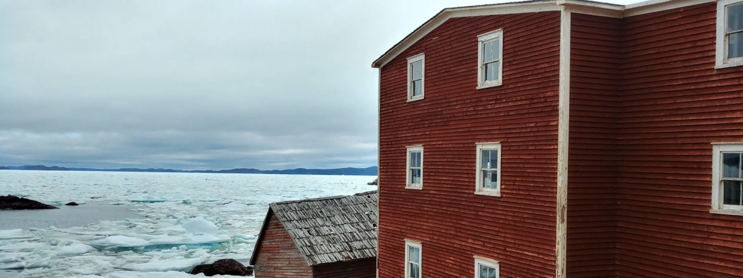
European settlers also made use of this natural pigment, which can be found in places known as ochre pits around the island. Boats, sails, and rope would be stained with ochre to help preserve them. If you look at the nearby heritage structure John Quinton’s Fish and Salt Store you will see that it has been painted with red ochre.
Red Sands and Lost Stories …
The distinctive red rocks that can be seen in this area are made from iron-cemented sandstone and other iron-rich sedimentary rocks, and lend several places, such as Red Cliff and Red Beach, their names. But the geology is also tangled up with legends, myths, and histories. Just to the northwest lies Bloody Bay, the site of an ancient rhyolite quarry. One story suggests that early in the colonial period, this place witnessed a violent encounter between Beothuk and settlers, and that is why it has its “Bloody” name. While this is now considered a myth, violence was a very real feature of encounters between the Beothuk and Europeans, especially asymmetrical violence visited upon the Beothuk by some settlers. It is far more likely that the blood-red rocks themselves are the reason for the Bay’s moniker, but these toponyms invite us to think about all the stories these rocks have witnessed over time.
Getting Here
Exit Route 235 at the Open Hall turn off. Continue driving until you reach Red Cliff. Search “John Quinton Limited Fish Store and Salt Store.” to get Google directions to the location. Don’t miss the Tickle Cove Sea Arch Geosite a few minutes further up the road.
Trail
While you are in the area, you might like to hike the short Red Beach Memorial Trail, a 2.4 km loop that leads to a distinctive nearby cove. The trail, located near Plate Cove West (11.3km south of Red Cliff on Route 235), is maintained by the local Plate Cove Trail Blazers, a community volunteer group dedicated to developing and caring for trails in the area.
| Distance | 2.4 km |
| Hiking Level | Easy |