There have been numerous ice ages in Newfoundland. The most recent one, the late Wisconsin Glacial Episode, began around 25,000 year ago, peaked around 18,000 years ago and ended somewhere between 13,000 and 8,000 years ago. During this time, the most northerly half of North America was covered in the Laurentide ice sheet, which was up to 3 km thick! The weight of these glaciers was so enormous that it caused parts of the continent to sink slightly into the earth’s mantle. With the melting of the ice sheet, sea levels rose, but the land rose faster meaning that the coast we see today around our geopark was very recently under as much as 20 metres of water. Scientists call the uplift of the land after an ice age isostatic rebound and it is still going on today. Characteristics of rebounding coastlines that we can see in the geopark include few-poorly developed-beaches, the narrow beaches we see have steep drop-offs and at some places we can even see marine terraces well above the present sea level. The marine terraces are above our modern shoreline not because sea level was higher so much as the land has been uplifted faster than sea level has risen.
Lookout Park has been a favourite swimming spot for decades. This ice-polished rock surface dips gently into the pond below. The sun’s heat warms the rock and making it a pleasant place to sit and dry off after a swim. This warm rock outcrop also warms the water making the temperature much higher in this pond than in some of the others on the peninsula.
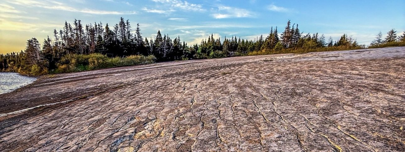
The slope of the rock is an ancient seafloor. If you look carefully you can see the shapes of ancient ripples which before polishing would have looked much like the geosite called The Ripples at Hodderville.
Marine Terrace
Marine terraces are areas where ancient beaches are far above where sea level is in present day.
As the ice sheets moved slowly over the land, they scraped off topsoil and dumped it offshore on the Grand Banks, making habitats suitable for seafloor creatures that are food for many commercial species, making it one of richest fishing grounds in the North Atlantic. Evidence of that glacial scour beneath the ice sheet can be seen here at Lookout Park because stones at the bottom of the ice sheet that were pressed onto bedrock gouged scratches into the surface.
Getting Here
From Route 230 take the Route 237 turn off. Turn right after you pass the Salvation Army Cemetery.
Flora/Fauna
Lookout Park in Trinity Bay North features classic boreal flora, including balsam fir, spruce, birch, and low-lying bog plants like Labrador tea and rhodora. The glacially polished rock and warm pond create unique microhabitats for mosses and heathland species. Visitors may spot wildlife such as red squirrels, snowshoe hares, and otters, while seabirds like puffins, kittiwakes, and bald eagles frequent the coastline. In summer, whales can often be seen just offshore, highlighting the area’s rich marine biodiversity.
Trail
Lookout Pond Park Trail (Catalina) is a family-friendly boardwalk loop around a serene glacial pond. It includes picnic spots and a flat-rock beach, making it ideal for a relaxed outing.
| Distance | 2km |
| Difficulty | Easy |
Nearby Trails
Arch Rock Trail (Little Catalina) is a short 1 km loop that leads to a dramatic natural sea arch. It’s a quick and scenic coastal walk with great ocean views.
Little Catalina to Maberly Trail is a longer, rugged coastal route featuring sea stacks, cliffs, and excellent chances to spot seabirds, whales, and icebergs. It’s best suited for adventurous hikers.
Murphy’s Cove Loop (near Port Union) is a peaceful 1 km singletrack trail that winds through wooded areas and along the shoreline—great for casual walks or trail runs.
Thompson’s Pond Park Trail (Port Union) is an easy 0.75 km loop with gentle terrain, a playground, picnic areas, and views of a freshwater pond—perfect for families and leisurely strolls.