This area represents a marine terrace – a relatively flat region that formed on the ocean floor near the
coastline more than 550 million years ago. Extensive glaciers covered this area more than 10,000 years
ago, and their immense weight caused the Earth’s crust to be pushed downwards into the underlying
mantle. When these glaciers melted several thousand years ago, the crust ‘rebounded’ upwards and
settled at its current level. Angle Pond was once a landward-reaching arm of the ocean, but was cut off
from the sea when the region rose to its current level; over thousands of years, the inflow of fresh water from rivers and rain has changed this water from saline (salty) to fresh. The glaciers in this region also scoured out deep trenches in the seabed. These trenches are well known feeding areas for sperm whales, known for being a deepwater species. Typically watching these whales is not possible this close to the shore, as one would have to be close to a volcanic island or off the continental shelf to see such depth. The rock is composed primarily of siltstones and sandstones, sediments that accumulated on the seafloor before glaciers covered the region. The surface of these rocks has been chemically altered since the glaciers melted, bleaching them to a pinkish-white color.
This is where White Point, to the east, gets its name. Numerous dips and folds are visible in the rocks here as a result of geological pressure, compressing them over thousands or even millions of years. Constructed in 2000 for the filming of the television miniseries Random Passage, this site is situated in the previously inhabited cove known as White Point. Today, it provides the opportunity to step back in time to learn more about the process of catching and preserving fish, early education, and our deep connection to the sea. The site tells the story of the realities of daily early outport life through guided tours of the sod houses, church, schoolroom, fish flakes, and fishing stage. Visitors are bound to leave with a new appreciation of our ancestors’ qualities of creativity determination and endurance required to survive and prosper in a place like this.
The Heritage Foundation of Newfoundland and Labrador (Heritage NL) was accredited in 2012 under the 2003 UNESCO Convention for the Safeguarding of Intangible Cultural Heritage. Heritage NL‘s Mentor Apprentice Program was created to support the teaching of endangered crafts and skills from an established mentor to an apprentice craftsperson or tradesperson. With the support of this program, a traditional ‘wriggle’ fence was constructed at the Random Passage Site.
Getting Here
Exit Route 230 at Lockton Route 239 turn off and proceed 17.7km to New Bonaventure. Park your vehicle at the Random Passage School House parking area.
Flora/Fauna
The area around New Bonaventure features coastal boreal forest and rugged headlands shaped by salt spray and wind. Tuckamore—dense mats of stunted spruce and fir—clings to exposed cliffs. Inland, groves of black spruce, balsam fir, tamarack, and alder grow in sheltered valleys and low hills. Ground cover includes mosses, lichens, crowberry, Labrador Tea, and bog plants such as pitcher plant and bakeapple. Wildlife includes foxes, snowshoe hare, and moose, while seabirds like puffins, murres, and bald eagles nest or hunt along the coast. Offshore, whales and seals are frequently seen during summer months. Tidepools host barnacles, mussels, crabs, and seaweed.
Cultural/Historical Attractions
New Bonaventure is home to the Random Passage Site, a recreated 19th-century fishing village constructed for the CBC mini-series Random Passage, based on the novels by Bernice Morgan. Set against the wild coastal landscape, the site includes traditional-style buildings such as saltbox houses, a church, and fish flakes. Guided tours offer insight into the daily life of early settlers and the challenges faced by Newfoundland’s outport communities.
The community also preserves its heritage through the Old School House, a former one-room school that now serves as a seasonal restaurant, heritage centre, and local craft shop. Visitors can enjoy traditional Newfoundland fare and browse handmade crafts created by local artisans, all while learning about the educational and cultural history of rural coastal life.
Trail
The British Harbour Trail is maintained by our partner, Hike Discovery Inc.
| Distance | 12.7 km |
| Hiking Level | Moderate-Difficult |
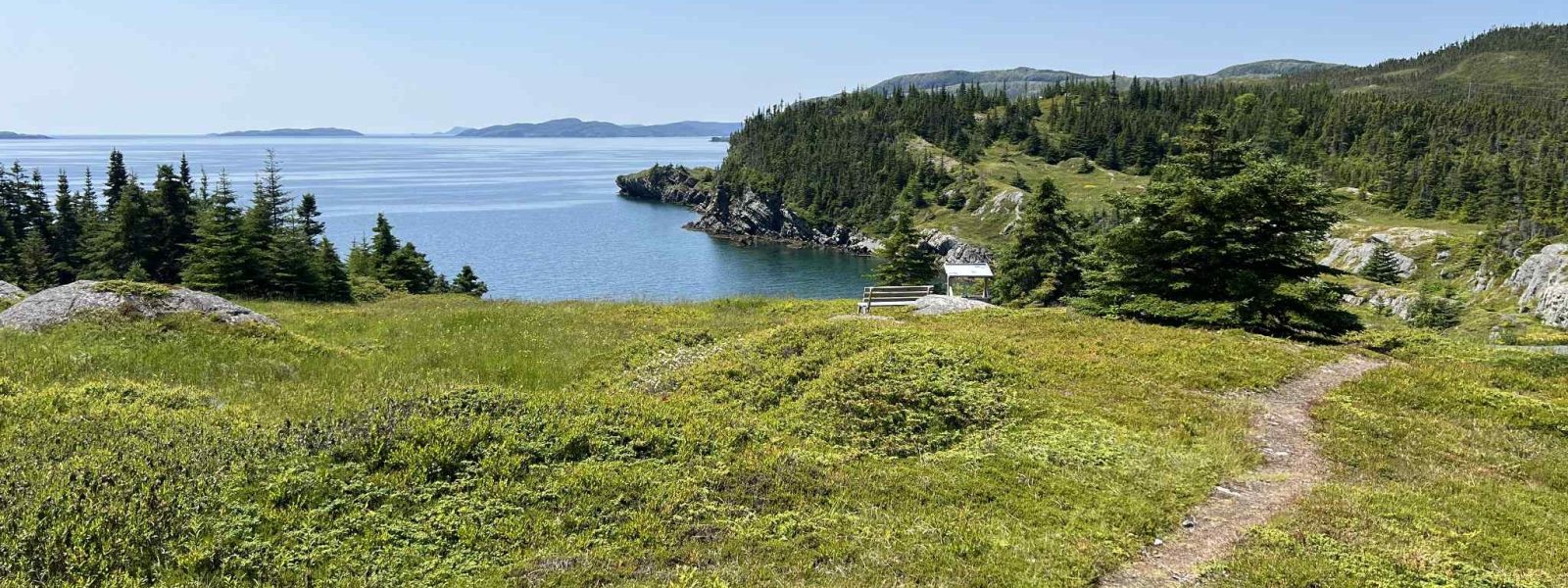
The British Harbour Trail begins in New Bonaventure and follows a scenic coastal route to the abandoned outport of British Harbour. Once home to a small but close-knit fishing community, the area was resettled in the 1960s as part of Newfoundland’s resettlement program. Along the trail, hikers can see remnants of stone foundations, and traces of garden beds, offering a moving glimpse into the lives once lived here. The trail winds through forest, open meadows, and rugged coastline, with sweeping ocean views and frequent seabird sightings. Interpretive signs along the way share the history of the community and its people. The full hike is moderately challenging and best suited for those with some hiking experience.
For those looking for a shorter option, the Kearley’s Harbour Trail offers a more relaxed hike along the same coastal landscape. This shorter out-and-back trail leads to a quiet, sheltered cove once used by local fishers, making it ideal for a peaceful walk with plenty of natural beauty and a taste of the area’s coastal heritage.